

お店のコメント(スペック情報を含む場合もあり)
内容説明 This volume is devoted to satellite radar interferometry (InSAR), a relatively new remote sensing technique used for geodetic applications such as topographic mapping and for high-accuracy monitoring of deformation of the Earth’s crust. It offers a geodetic perspective of the technique, using a functional and a stochastic model to describe the relation between the observations and parameters and to discuss issues such as accuracy, robustness, and error propagation. It explains both theory and applications and provides a resource for future studies in the field. Radar Interferometry presents a geodetic technique, complementary to GPS, laser altimetry, photogrammetry, and leveling and comments on its pros and cons for various applications. It features the technique of radar interferometry meteorology, a new application in the field of atmospheric studies. Fine-resolution mapping of the atmospheric water vapor distribution offers new insights for meteorologists. Audience: Radar Interferometry: Data Interpretation and Error Analysis is designed for researchers and professionals in geodesy, geophysics, and meteorology that can benefit from the use of remote sensing using interferometric radar.

お店
アマゾン (amazon)

お店の商品コード
9048156963
JANコード
-
メーカー

商品ジャンル
商品名
最終調査日時
2016/01/27 (Wed) 04:06:50
価格の変動(直近3回 : ¥0は未調査回)
取得日時
販売価格
ポイント
実質価格
在庫状態
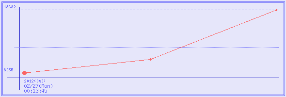
2016/01/27 (Wed) 04:06:50
¥18,682
0 %
¥18,682
2012/08/26 (Sun) 21:21:49
¥10,298
0 %
¥10,298
2012/02/27 (Mon) 00:13:45
¥8,055
0 %
¥8,055
サイト内キーワード検索
商品名の検索は通常の商品検索ボックスで。
コメントやスペックなどから検索したい場合はこちらから。
コメントやスペックなどから検索したい場合はこちらから。
広告